


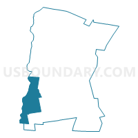
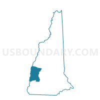
TOWN OF CHARLESTOWN Voting District, Sullivan County, New Hampshire
About
Outline

Summary
| Unique Area Identifier | 616492 |
| Name | TOWN OF CHARLESTOWN Voting District |
| County | Sullivan County |
| State | New Hampshire |
| Area (square miles) | 38.05 |
| Land Area (square miles) | 35.80 |
| Water Area (square miles) | 2.25 |
| % of Land Area | 94.10 |
| % of Water Area | 5.90 |
| Latitude of the Internal Point | 43.24663400 |
| Longtitude of the Internal Point | -72.38393120 |
Maps
Graphs
Select a template below for downloading or customizing gragh for TOWN OF CHARLESTOWN Voting District, Sullivan County, New Hampshire


Neighbors
Neighoring Voting District (by Name) Neighboring Voting District on the Map
- CLAREMONT WARD 2, Sullivan County, NH
- Rockingham Voting District, Windham County, VT
- Springfield District 2, Windsor County, VT
- TOWN OF ACWORTH Voting District, Sullivan County, NH
- TOWN OF LANGDON Voting District, Sullivan County, NH
- TOWN OF UNITY Voting District, Sullivan County, NH
- TOWN OF WALPOLE Voting District, Cheshire County, NH
Top 10 Neighboring County Subdivision (by Population) Neighboring County Subdivision on the Map
- Claremont city, Sullivan County, NH (13,355)
- Springfield town, Windsor County, VT (9,373)
- Rockingham town, Windham County, VT (5,282)
- Charlestown town, Sullivan County, NH (5,114)
- Walpole town, Cheshire County, NH (3,734)
- Unity town, Sullivan County, NH (1,671)
- Acworth town, Sullivan County, NH (891)
- Langdon town, Sullivan County, NH (688)
Top 10 Neighboring Place (by Population) Neighboring Place on the Map
Top 10 Neighboring Elementary School District (by Population) Neighboring Elementary School District on the Map
Top 10 Neighboring Secondary School District (by Population) Neighboring Secondary School District on the Map
Top 10 Neighboring Unified School District (by Population) Neighboring Unified School District on the Map
- Claremont School District, NH (13,355)
- Fall Mountain Regional School District, NH (12,364)
- Springfield School District, VT (9,373)
Top 10 Neighboring State Legislative District Lower Chamber (by Population) Neighboring State Legislative District Lower Chamber on the Map
- State House District 4, Sullivan County, NH (16,180)
- State House District 2, Cheshire County, NH (9,280)
- Windsor-1-2 State House District, VT (9,247)
- Windham-4 State House District, VT (7,352)
- State House District 5, Sullivan County, NH (6,693)
Top 10 Neighboring State Legislative District Upper Chamber (by Population) Neighboring State Legislative District Upper Chamber on the Map
- Windsor State Senate District, VT (56,670)
- State Senate District 8, NH (54,222)
- Windham State Senate District, VT (42,637)
Top 10 Neighboring 111th Congressional District (by Population) Neighboring 111th Congressional District on the Map
Top 10 Neighboring Census Tract (by Population) Neighboring Census Tract on the Map
- Census Tract 9757, Sullivan County, NH (5,114)
- Census Tract 9666, Windsor County, VT (5,075)
- Census Tract 9758, Sullivan County, NH (4,712)
- Census Tract 9667, Windsor County, VT (4,298)
- Census Tract 9759.02, Sullivan County, NH (3,948)
- Census Tract 9702, Cheshire County, NH (3,734)
- Census Tract 9670, Windham County, VT (3,251)
- Census Tract 9756, Sullivan County, NH (3,250)
- Census Tract 9671, Windham County, VT (2,031)
Top 10 Neighboring 5-Digit ZIP Code Tabulation Area (by Population) Neighboring 5-Digit ZIP Code Tabulation Area on the Map
- 03743, NH (14,103)
- 05156, VT (9,226)
- 03603, NH (5,412)
- 05101, VT (4,643)
- 03608, NH (2,811)
- 03602, NH (2,654)
- 03609, NH (854)
- 03601, NH (477)